What are Supercontinents?
Tatjana Somer & Damian Pang | 16 December 2021
A Broken-Up Jigsaw-Puzzle?
Almost 500 years ago the Dutch cartographer Abraham Ortelius (1527-1598) observed in his work Thesaurus Geographicus (1596) that the coastlines of the continents across the Atlantic seem to match up1. Many other geographers have picked up on this idea over the centuries, but it was only in the early 1900s when a German geophysicist Alfred Lothar Wegener (1880-1930) turned it into a proper scientific theory: continental drift2. Wegener suggested that all land was once combined into a single, unified supercontinent that he named Pangea (which is Greek for “all the earth”) 3,4 .
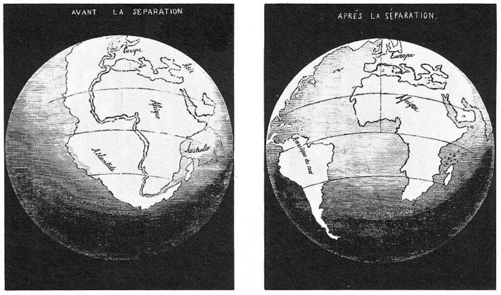
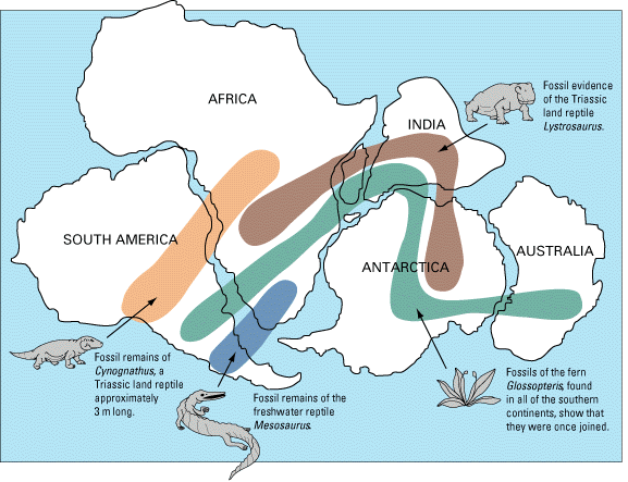
Supporting evidence for the movement of continents and for historic supercontinents came from the distribution of ancient fossils, rocks, and mountain ranges and also from indications of changes in climate zones6, such as fossils of ferns in areas that are now polar regions7. Wegener not only agreed with Ortelius’ idea of coastlines across the Atlantic fitting together like a puzzle but also observed how South America, India, Australia, and Africa had bands of almost identical Paleozoic rocks and fossils8. He presented the idea that continents moved around and that the present configuration resulted from the splitting of a large landmass that previously contained all of the world’s continents9.
More recent geological research indicates that Pangaea was not the only supercontinent in Earth’s history but that several supercontinents assembled and broke up in a repeating pattern called the supercontinent cycle10.
Moving Plates
Wegener’s idea of continental drift gave rise to another scientific theory that describes the underlying reasons for landmasses moving over time and why supercontinents keep forming and breaking up: plate tectonics. Our planet is not static—as we can witness when an earthquake strikes or a volcano erupts—but is a dynamic place that changes constantly. The solid land we see and the ocean floor a part of what is only a very thin layer on the very edge of our planet called the crust, which is broken up into different tectonic plates that “float” on top of molten rock
The Earth’s interior is divided into three layers: The core, the mantle, and the crust. The crust, together with the upper part of the mantle creates lithosphere which is divided into tectonic plates. They can be continental or oceanic and some of them are Eurasian, African, Pacific, etc. The plates slowly move, so the continents change their position over time. The plates move because of the higher temperature and pressure in the Earth’s mantle that then behaves plastically allowing plates to move.4
The beginning
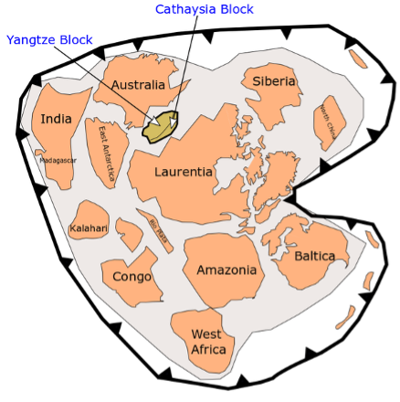
What we now have: continents, oceans, atmosphere was an unfamiliar thing in Earth’s early stage of development. Most scientists agree that the formation of Earth began before 4.6 billion years, and the Earth was then just a ball of fire. When cooled down the first Earth’s crust was formed in little fragments. Those fragments joined together in one of the first known supercontinents called Rodinia about 1.2 billion years ago.1 The landmass can only be named a supercontinent if it holds all or nearly all the Earth’s continental blocks. 11
Rodinia
Rodinia was the dominant landmass of the Earth for at least 350 million years, and the name comes from Russian, meaning homeland.1
It is impossible to determine the exact size and configuration of the first continent, but as seen in the image, most of Rodinia’s landmass is what is now North America. Rodinia split into two halves about 750 million years ago creating the Panthalassic ocean.3 Between the two parts of Rodinia stayed Congo craton which is now Central Africa.3
The fragments of the continent slowly began to come back during the Paleozoic era, which started around 540 million years ago. In the Permian period (300 million years ago) once again, the continents came together to form a new supercontinent. But why and how did it all happen?
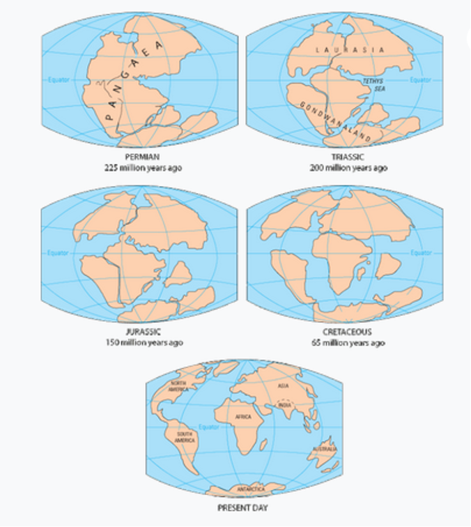
Pangea
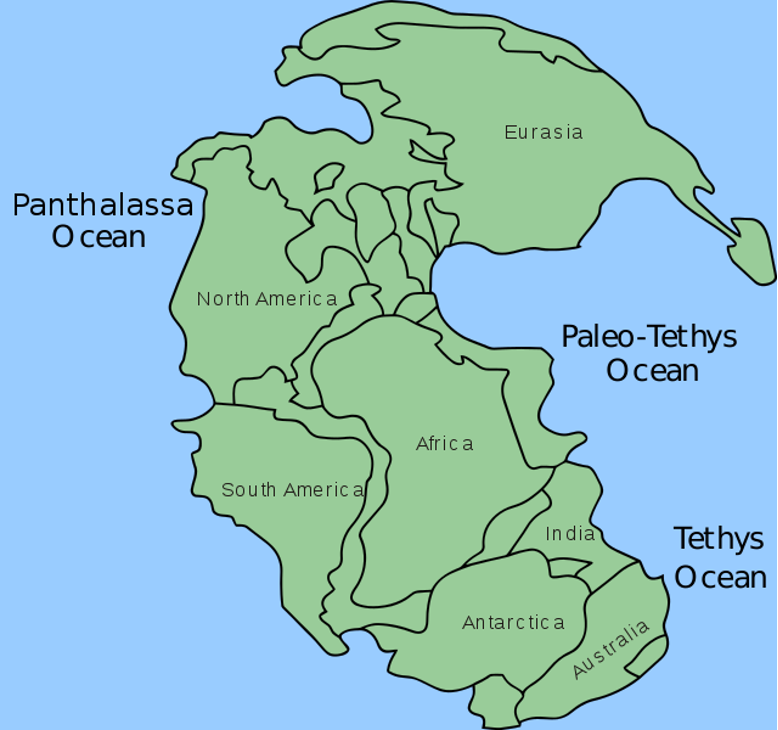
Pangea has fully assembled about 280 million years ago and started to break apart some 70 million years later.5 Pangea was surrounded by the Panthalassa Ocean while in the eastern part was Tethys ocean. Pangea initially separated into two parts: Laurasia became the northern supercontinent, containing what is now North America and Eurasia, but without India, and the southern one, Gondwana, composed of all the present-day continents from the southern hemisphere and India4 which drifted north, collided with south Asia, creating the Himalayan mountain range. Two new oceans were born: Atlantic (which still increases in size because the European and North American plates drift apart ) and Indian.
The future
What will happen in the future no one can tell for sure, but the Earth will never be the same as it is now. Tectonic plates will collide, creating new mountain ranges; breaking apart, creating new seas and oceans, or passing by one another causing massive earthquakes. It is believed that all the earth’s continental blocks joined together into one landmass at least three times in earth history, the oldest assembly was probably Columbia and mentioned before, Rodinia and Pangea2 So sometime in the future that supercontinent cycle will happen once again, continents will join together creating a new supercontinent, just proving that everything on Earth has its own cycles and our planet is one interesting place to be.
The term supercontinent is a bit fuzzy but some researchers have defined it as any landmass that includes at least 75% of the continental crust in existence at the time12. All these criteria are based on Pangaea, the supercontinent we know most about and the first to be classified. It was the discovery of Pangaea that led to the acceptance of the theory of continental drift and Pangaea served as the archetype of what a supercontinent is13.
Pangaea is not the only supercontinent in earth’s history. In fact the best evidence suggests that supercontinents form and break up in repeating cycles14. Identifying ancient continents is difficult but there is substantial evidence for at least two more besides Pangaea: Rodinia, and Columbia15. Depending on the criteria used to define what a supercontinent is, half a dozen more could be added starting with the ancient landmass of Ur16 to Pannotia17 (from which Gondwana split and later combined with Laurasia to form Pangaea18. What is clear is that Pangaea was neither the first nor only supercontinent.
1 https://www.burkemuseum.org/geo_history_wa/Dance%20of%20the%20Giant%20Continents.htm
2 Rogers, J.W. John & Santosh, M. (2004): Continents and supercontinents, Oxford University Press
3 http://www.scotese.com/info.htm
4 Plummer, McGeary & Carlson (2001): Physical Geology, McGraw – Hill, New York, 2001.
5 https://www.britannica.com/place/Pangea
1 USGS. (2012). Historical Perspective. United States Geological Survey. URL: https://pubs.usgs.gov/gip/dynamic/historical.html
2 Encyclopaedia Britannica (2021). Alfred Wegener. Encyclopedia Britannica. URL: https://www.britannica.com/biography/Alfred-Wegener
3 Harper, D. (n.d.). Etymology of Pangaea. Online Etymology Dictionary. URL: https://www.etymonline.com/word/Pangaea
4 Plummer, C., McGeary, D. & Carlson, D. (2001). Physical Geology [9th ed.]. New York, NY: McGraw – Hill.
5 Affolter, M., et al. (2020). Historical geology. Piedmont, VA: Piedmont Virginia Community College.
6 Schulte, K. (2021). Fundamentals of geology. Davis, CA: LibreTexts.
7 USGS. (2012). Historical Perspective. United States Geological Survey. URL: https://pubs.usgs.gov/gip/dynamic/historical.html
8 Plummer, C., McGeary, D. & Carlson, D. (2001). Physical Geology [9th ed.]. New York, NY: McGraw – Hill.
9 Rogers, J. J. W., & Santosh, M. (2004). Continents and supercontinents. Oxford, UK: Oxford University Press.
10 Mitchell, R. N., et al. (2021). The supercontinent cycle. Nature Reviews Earth & Environment, 2, 358–374. https://doi.org/10.1038/s43017-021-00160-0
11 Rogers, J. J. W., & Santosh, M. (2004). Continents and supercontinents. Oxford, UK: Oxford University Press.
12 Meert, J. G. (2012). What’s in a name? The Columbia (PaleoPangaea/Nuna) supercontinent. Gondwana Research, 21(4), 987-993. https://doi.org/10.1016/j.gr.2011.12.002
13 Meert, J. G. (2012). What’s in a name? The Columbia (PaleoPangaea/Nuna) supercontinent. Gondwana Research, 21(4), 987-993. https://doi.org/10.1016/j.gr.2011.12.002
14 Mitchell, R. N., et al. (2021). The supercontinent cycle. Nature Reviews Earth & Environment, 2, 358–374. https://doi.org/10.1038/s43017-021-00160-0
15 Mitchell, R. N., et al. (2021). The supercontinent cycle. Nature Reviews Earth & Environment, 2, 358–374. https://doi.org/10.1038/s43017-021-00160-0
16 Rogers, J. J. W., Santosh, M. (2003). Supercontinents in earth history. Gondwana Research, 6, 358-368. https://doi.org/10.1016/S1342-937X(05)70993-X
17 Nance, R. D., & Murphy, J. B. (2018). Supercontinents and the case for Pannotia. Geological Society, London, Special Publications, 470, 65-86. https://doi.org/10.1144/SP470.5
18 Rogers, J. J. W., & Santosh, M. (2004). Continents and supercontinents. Oxford, UK: Oxford University Press.